Storm Bram arrived in early December 2025 and immediately made its presence felt along the Cornish coast, including on Penzance promenade. A deep Atlantic low pressure system, officially named Storm Bram by the Irish meteorological service and recognised by the UK Met Office, brought a combination of very strong winds, unusually high waves and persistent heavy rain to much of the UK and Ireland. In West Cornwall, that translated into dramatic scenes of waves crashing over the sea wall, sea spray drifting right across the road and conditions that made even a short walk along the prom feel wild and exposed.
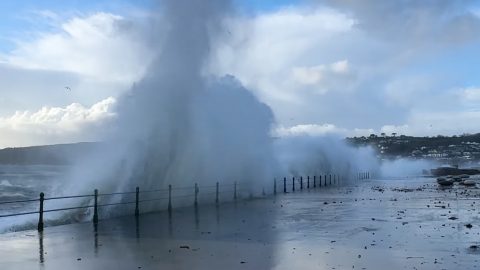
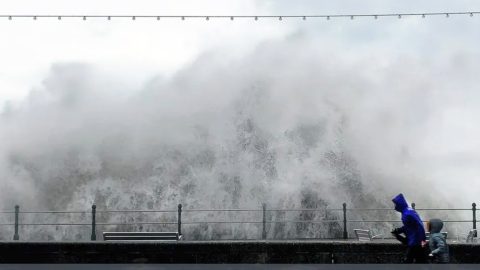
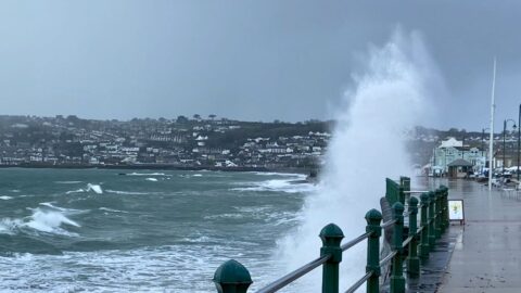
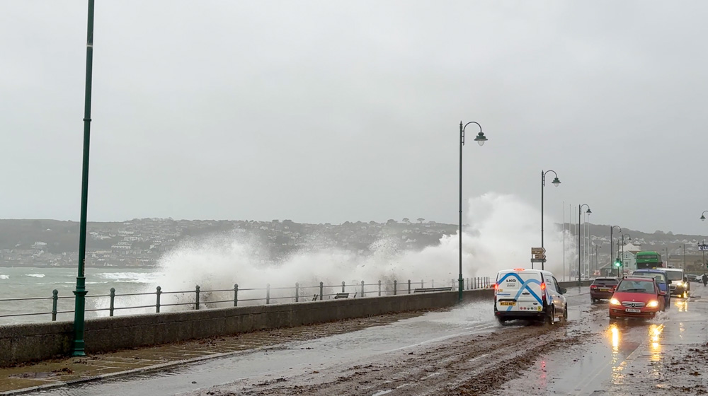
This short video, filmed from Penzance promenade, captures some of the most powerful waves generated by Storm Bram as they slam into the sea wall and send plumes of white water curling over the railings. You can see waves breaking across the road, spray covering passing cars and bursts of foam racing along the pavements. Even on camera it gives a good sense of just how energetic the sea becomes here when a major Atlantic storm coincides with onshore winds and a high tide.
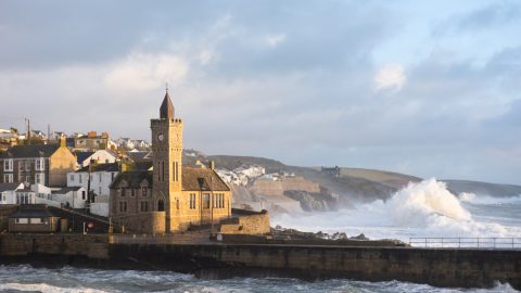
For context, this stretch of promenade looks out across Mount’s Bay towards Newlyn and St Michael’s Mount. On calmer days it is a gentle place for a walk, with benches, wide pavements and views across the bay. During Storm Bram, that familiar seafront was transformed, with each new wave surging higher than the last and the sound of the sea dominating everything.
What made Storm Bram so powerful?
Storm Bram was an extra tropical cyclone which developed over the Atlantic before tracking towards Ireland and the UK. It was a classic mid latitude low pressure system, the type that regularly brings autumn and winter storms to our shores, but Bram was notable for the strength of its winds and the amount of rain it carried. It was also classified as a Shapiro Keyser type cyclone in meteorological terms, a structure that can lead to strong pressure gradients and very intense wind fields near the storm centre.
Met Éireann named the system Bram on 8 December 2025 because of its expected impact on Ireland, and the Met Office adopted the same name as it issued weather warnings for the UK. Forecasts highlighted a very wet and windy spell for northern and western parts of the country, with particular concern for exposed coasts and higher ground. Meteorologists warned that Bram would deepen as it moved in, tightening the pressure gradient and increasing wind speeds around the southern and western flanks of the low.
Across western parts of the UK, gusts of 50 to 60 mph were widely expected, with some coastal areas seeing gusts closer to 70 mph. In northwest Scotland, the strongest gusts were forecast to reach around 90 mph in exposed locations. At the same time, Bram was expected to deliver large amounts of rain, with parts of south Wales and Devon seeing close to 100 millimetres of rainfall falling onto ground that was already saturated after an unsettled spell of weather.

Weather warnings and impacts across the UK and Ireland
As Bram approached, the Met Office issued a combination of yellow and amber weather warnings for wind and rain. Amber warnings were in force for northwest Scotland and parts of northern and western Britain, highlighting a risk of damage to buildings, power lines and trees as well as the possibility of large waves along exposed coasts. Yellow warnings stretched more widely across Wales, southwest England and much of Scotland, reflecting the broader area of strong winds and heavy rain associated with the storm.
In Ireland, Met Éireann issued Status Orange wind warnings for many coastal counties and a Status Red warning for some marine and coastal areas, indicating violent storm force gusts over the Atlantic and Irish Sea. These warnings emphasised the risk of coastal flooding, hazardous driving conditions and disruption to travel.
As Bram moved through, those forecasts translated into real impacts. Flights were cancelled at several airports, particularly in Ireland and parts of the UK, as crosswinds and turbulence made take offs and landings unsafe. Ferries across the Irish Sea were delayed or cancelled as high seas and gale force winds made conditions too rough. On the roads, fallen trees, flooding and spray reduced visibility and forced temporary closures on some major routes, and in Scotland there were reports of heavy goods vehicles being blown onto their side on exposed stretches of motorway.
Rail services also felt the effects. Some routes imposed speed restrictions because of the risk of debris or fallen trees on the line, while others were temporarily suspended in the worst affected areas. Thousands of homes were left without power at various points as high winds brought down lines or damaged infrastructure, particularly in parts of southwest England, Wales and Scotland.
Storm Bram in West Cornwall
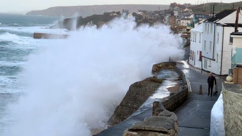
Here in West Cornwall, Storm Bram arrived with long fetch Atlantic swell meeting strong onshore winds. Along the stretch from Newlyn to Penzance, Longrock and Marazion, seafront properties were put at risk from overtopping waves and wave driven spray. Coastal flood guidance highlighted the possibility of localised flooding around high tide, along with potential damage to sea front railings, sea walls and exposed shopfronts facing the water.
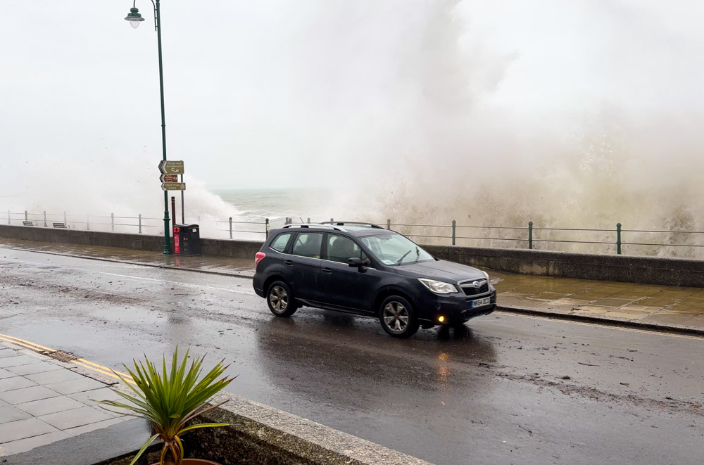
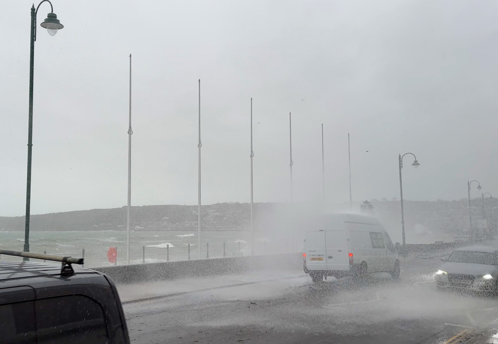
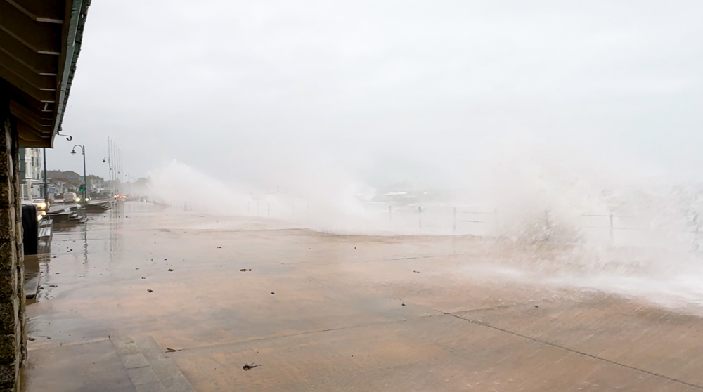
On Penzance promenade itself, the combination of powerful swell and wind driven waves pushed water right up against the wall. At times, individual sets of waves broke in just the right way to climb the full height of the structure and spill over onto the road and pavements behind. For anyone watching, each set became a sequence of booming impacts followed by an explosion of white water and spray that could be felt, not just seen.
The promenade is used to rough weather, especially during the autumn and winter storm season, but Bram still felt significant. Drivers slowed or stopped as waves broke over the carriageway and visibility dropped under sheets of spray. Pedestrians who had ventured out for a look quickly learnt to time their dash between the larger sets to avoid a full drenching from head to toe.
How Storm Bram fits into a wider pattern
Storm Bram is one of a series of named storms during the 2025 to 2026 European windstorm season. Each named storm reaches the threshold because of its potential to cause impacts such as travel disruption, power cuts or coastal flooding, rather than simply because of wind speed alone. In Bram’s case, it was the combination of very strong winds, prolonged heavy rain and already saturated ground that made it a concern for forecasters.
Recent years have seen several similar systems bring intense rainfall and periods of very strong winds to the UK and Ireland, particularly during the autumn and winter months. Meteorologists note that a warmer atmosphere can hold more moisture, which can increase the intensity of rainfall events associated with Atlantic storm systems. That does not mean any single storm can be attributed to climate change by itself, but it does provide important context for why some of the wettest and windiest episodes can feel more disruptive than they might have done in the past.
For coastal communities like Penzance, that means keeping a close eye on official forecasts and warnings during the storm season, and being ready for days when the sea spills over the usual boundaries of the promenade and onto roads and pavements. When the warnings are in place, the safest way to experience conditions like this is via video or from a secure, elevated viewpoint well back from the water’s edge.
Once Bram has passed, Mount’s Bay will settle down again into more familiar winter patterns, with calmer days returning between the next batch of Atlantic systems. For now, this video offers a snapshot of one particularly wild morning on Penzance promenade as Storm Bram showed what the Atlantic is capable of when conditions line up just right.